What a Communist City Can Teach Us About Urban Planning
Renamed after Italian Communist leader Palmiro Togliatti, the Russian city of Tolyatti was chosen as home for a FIAT-backed auto plant in 1966, soon making it the USSR’s largest planned industrial center. Yet its urban landscape shows signs of planners’ concern to create livable spaces focused on community need, not just industrial production.

View at sunset from the sixteenth floor of one of the highest Soviet residential buildings in Avtozavodsky district. The district's simple geometry and modular structure are visible, as well as its lack of natural constraints to development, with the seemingly endless steppe beyond city limits. (Photo by Michele Cera)
In summer 1966, the Soviet state signed an agreement with management at leading Italian auto firm FIAT. Their plan was to build a new car factory in the USSR, with the Turin-based company responsible for the technological installations and the training of specialists. The factory was meant to be the heart of a new urban settlement hosting factory workers, technicians, and managers, including — for a few years — the specialized Italian workers and engineers.
The chosen location was a young city in the Kuybyshev (today, Samara) region of western Russia, in 1964 renamed after the recently deceased Italian Communist leader, Palmiro Togliatti. On the Italian side, the symbolic implications were obvious. Togliatti’s successor Luigi Longo visited the city in August 1966; Pravda quoted him stressing the significance of Torinese workers and technicians coming to a city named after Togliatti — and expressing hopes that in a few months the city might turn into a sort of Soviet Turin.
The story of the factory and the new urban settlement is often framed as a highly uncommon occurrence, during the Cold War, of Western technological support to Soviet modernization. Yet this episode is emblematic of late Soviet history, with regard to two key aspects of the post-Stalinist USSR. It speaks to both the transformative ambitions of urban planning, and the professional — and, to an extent, political — elites’ technocratic mindset, informing their pragmatic attitude toward drawing lessons from international, and Western, architectural and technological trends.
A Company Town
In the late 1940s, Stavropol-na-Volge (Stavropol-on-Volga) was a two-centuries-old small town of a few thousand inhabitants on the shore of the river Volga. Yet just a few decades later — now renamed as Tolyatti — it had become the largest planned industrial city in the USSR.

The first step of this ambitious urbanization project was the construction, in the first half of the 1950s, of a dam and hydroelectric power station on the Volga. An urban district, Komsomolskiy rayon (Komsomol district), was built to accommodate the plant’s builders, and a second one — today named Tsentral’nyy (Central) – followed soon after. By the first half of the 1960s, the population had grown to more than a hundred twenty thousand inhabitants. But the definitive boost to city development came from the need — identified by the Soviet government as a strategic priority — to develop the country’s auto production capacity, in order to meet the growing demand of the population for private transport. To this end, a brand-new factory was deemed necessary, also relying on the technological support of foreign specialists.
The choice fell upon FIAT, one of the world’s leading producers of budget cars. After the signing of the cooperation agreement which put the Italian company in charge of the technical project, in July 1966, the Soviet authorities authorized the construction of a large factory a few miles west of Tsentral’nyy rayon. The works began at the start of 1967; almost immediately after, in March, the building of residential housing around the factory site started at a fast pace. This was the birth of Avtograd, today Avtozavodskiy rayon (“auto-factory district”), the largest neighborhood of Tolyatti — originally conceived as a new town in its own right, and one of the most ambitious urban planning projects in the postwar USSR.

To understand this project we need to consider at least three elements: the relationship between ideology, urban planning, and space in the USSR; the automotive factory as a response by the Soviet state to the demand for private transport that had emerged in the years of relative liberalization which followed Stalin’s death; and the trends and practices of Soviet planning and architecture in the late 1960s.
The company-town model was hardly unique to the USSR and Eastern Bloc countries, but it was a key element of Soviet ideology throughout that state’s history. Since the post-revolutionary years, new urban settlements were attributed a central role in the creation of a new communist society, in line with the Constructivist tenet according to which “a new society needs a new space.” New towns, initially mostly associated with the mining/extractive industry, were built from the early 1930s onward; and the strict relation that was envisaged in the Stalin years between urban space, welfare, and industry strengthened their ideological relevance.

However, the USSR in the mid-1960s was in many respects a different country then it had been in the years of high Stalinism, one of the most significant shifts being in the domain of urban planning. The so-called Khrushchev Thaw from the mid-1950s brought relative liberalization and renewed aspirations — however partial and contradictory — which sought to revive the radical egalitarian utopianism of the 1920s.
Faced with a dramatic housing shortage deepened by wartime devastations, and with significant socio-spatial segregation and inequality between elites and workers, the Soviet state launched a large-scale mass housing program all across the country. Accompanied by a rejection of the architectural neoclassicism that had dominated since the early 1930s, in favor of a return to the international modernist style, this was a technocratic plan to confront emergency shortages, but at the same time an ambitious measure of universal welfare, and an attempt at projecting the egalitarian state ideology in urban space, in order to promote a new way of life (byt’) meant to prepare the transition to a communist society.
The new central element of this program was the micro-district, a new type of residential complex consisting of prefabricated panel buildings separated by yards provided with playgrounds, green space, and, at least in theory, educational, cultural, and health services. The architecture was hyper-standardized and based on cheap materials, but the planning was innovative; it sought to break out of the socio-spatial segregation that had characterized the Stalin period by creating an environment in which almost all kinds of people would live, and gave way to a specific balance between private — families were given their own apartments, moving away from shared communal houses — and collective space.
Yet while the scale and pace of the program was impressive, it was structurally flawed due to its enormous ambitions, which led to the definition of impossible targets, and to the emphasis on mono-dimensional quantitative goals — to a large extent an influence of the main heritage of the Stalin years, namely central planning; as such, problems such as poor execution, project delays, and budget shortfalls were common from the very beginning.
In this context, company towns — that were ideally meant to represent “classless cities” — became specific socio-spatial environments where the company-owned residential housing and service infrastructure was responsible for welfare provision, giving way to an interconnected system and, hence, to a distinctive community and way of life.

Designing Avtograd
The new climate and changes in lifestyles led to a growing demand for mass consumption goods, including private transport. The high strategic priority assigned to the VAZ plant and the new town also reflected the Soviet state’s aim to deal with this demand, not adequately met by preexisting producers. After the mining cities of the 1930s and the science/energy towns of the postwar period, Avtograd was then the first representative of a third generation of company towns: the motor town.
As a technocratic response to supply shortage, and to social pressure for mass consumption, it represented the application of Fordist principles — the epitome of productivity — to mass production, with Detroit as idealized example. On the other hand, these factories and towns were also planned to fulfill ideological and propaganda purposes, in which motorized transport embodied a vision that suited Soviet longing for the city of the future and projected an image of novelty and modernity. In other words, the Western technological innovation conveyed by FIAT’s expertise was incorporated into a distinctly Soviet project.
The construction of the VAZ factory and Avtograd had been envisaged in the final year of Khrushchev’s rule. The ousting of the reformist leader led — after a short, still relatively dynamic period characterized by prime minister Alexey Kosygin’s attempted economic reforms — to the Brezhnev period, later known as the “Era of Stagnation.” This period marked a significant reversal of political liberalization processes, a hard blow to hopes of “reforming the USSR from within,” and a shift to (a)political conformism, albeit in a context of economic stability that lasted for more than a decade.
Despite the substantial continuity of strategies and policies with the Thaw years, urban planning discourse consequently shifted from egalitarian ideology to a basically technocratic view of universal welfare provision, with right to housing and right to work as key elements of the social pact between the state and its worker-citizens. The focus was now on material improvement; and new directives focused on the increase of living space per person and the quality of housing materials. Avtograd was the product of this complex historical and political-ideological context.

The planning of the new district was entrusted to the architect Boris Rubanenko. He had received his education in the modernist avant-garde years and had led a successful career since the 1930s, when he developed an architectural synthesis that managed to incorporate some modernist elements into the then-official neoclassicist style.
After Stalin’s death, he embraced the return to international modernism, and hence by the period of Avtograd’s construction in the late 1960s, his urban planning views were influenced both by his educational and professional background, and by contemporary international principles and trends. These influences were embodied by the Avtograd plan, drawing inspiration from the Soviet planning theorists of the 1920s (in particular, the concepts of linear development and parallel functional zones elaborated by Nikolai Milyutin), but also from planned-city experiments outside the Eastern Bloc, in particular Brasilia, the new capital city of Brazil planned a few years earlier by Oscar Niemeyer and Lúcio Costa.
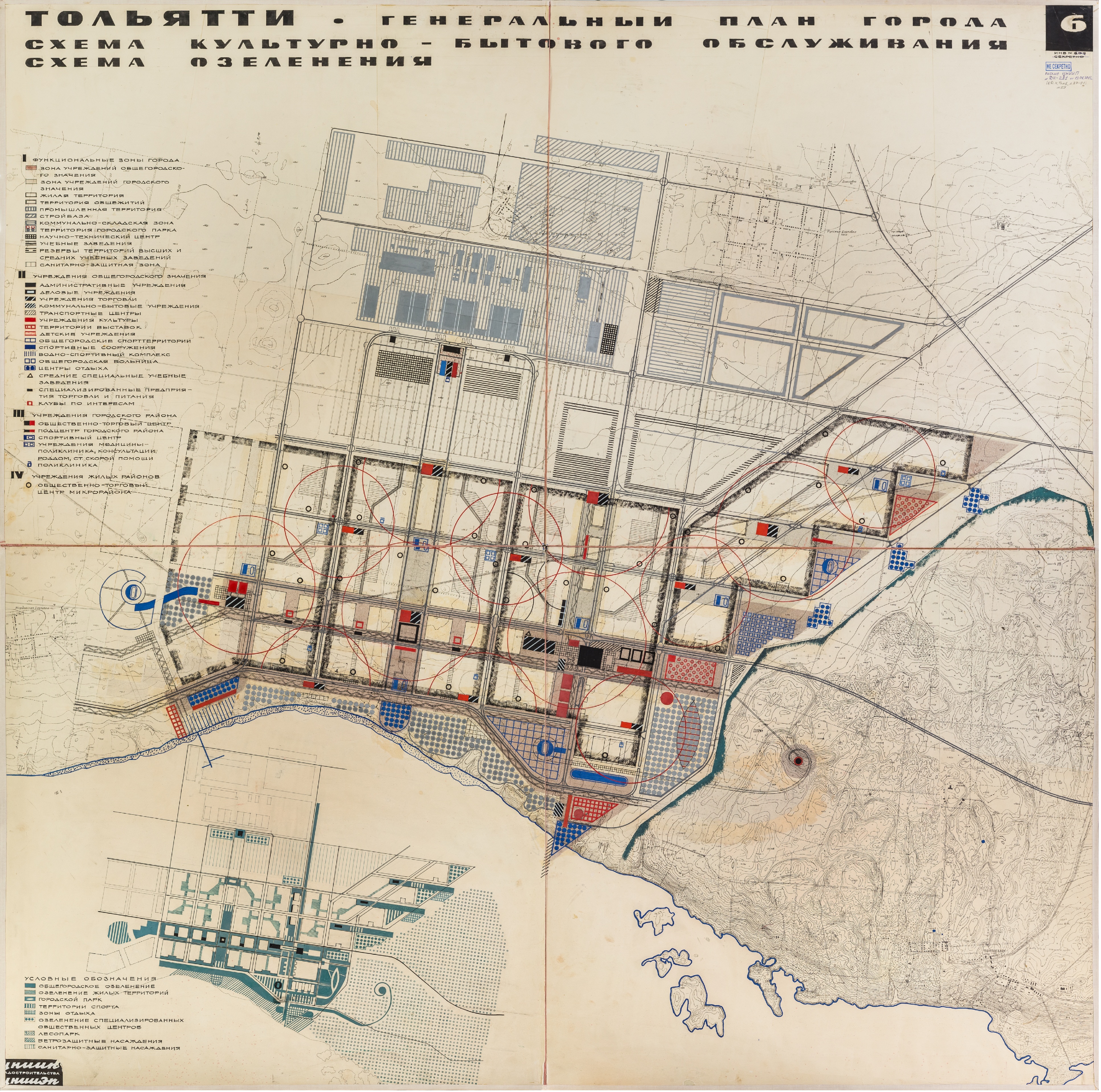
The district plan (see here) was based on an orthogonal structure, with two perpendicular esplanades dividing it into four unequal parts. The vertical axis connected the factory territory with the Volga embankment. Avtograd was divided into residential districts, in turn broken down into micro-districts. The main area unit for the micro-district, and the most important area for everyday social interaction, was an enlarged kvartal (residential block) with the typical characteristics of Soviet mass housing planning of the late 1960s to early 1970s: nine- or twelve-story panel residential buildings demarcating a large semi-open courtyard, a green common space including educational facilities, a sports field, and a playground.
The first residential buildings also included, in a manner partly reminiscent of the constructivist experiments of the 1920s and ’30s, a sort of “communal block” for recreational and cultural services, from libraries to chess clubs. The large avenues, apt for a “motor town,” were designed for motorized rather than pedestrian transport, according to the principles that Le Corbusier had outlined a few decades earlier.
Given the important role attributed to spaces for collective cultural and recreational use, several large public buildings were envisaged, from houses of culture and sports palaces to cinemas and theaters. These spaces, too, expressed a mix of historical and cultural influences and elements: the socio-spatial egalitarian ambitions of the 1920s Constructivist avant-garde, the monumental view of culture inherited from Stalinism, the contemporary modernist ambition of bringing higher comfort and quality of life to society through urban planning.
Moreover, public buildings allowed architects to express their artistic ambitions differently from the overly standardized requirements of residential housing. The largest and most ambitious of them, the House of Culture, Art and Creativity (DKIT), was planned to be the main landmark and perceived central point of the district.

Yet these ambitions soon had to deal with severe obstacles. Strong pressure on the welfare system emerged from the mid-1970s, leading to growing budget constraints; coupled with the chronic inefficiency of central planning, this led to the systematic delay of welfare infrastructure development at all city levels.
In many cases, service facilities were only built several years after the residential housing in housing blocks, and significant delays also affected the construction of recreational buildings. The DKIT, planned in 1971, was built only in the mid-1980s. By the end of the decade, the crisis of the planned or command economy model in the emergence of global post-Fordism further worsened the trend — and led to significant welfare cuts. As a result, the city fulfilled the enactment of the Soviet social pact based on the right to stable work and housing, but at the same time, in the words of both Western and Soviet observers, had resulted in an environment characterized by a lack of street life, anomie, and sensorial deprivation.
After the Fall
Nowadays, Avtozavodskiy rayon has a population of about 430.000 inhabitants, more than half of the overall population of Tolyatti, over a territory of thirty-four square miles. As with most Soviet mono-industrial settlements, it is struggling in the context of the global market economy. VAZ, renamed AvtoVAZ — now with Renault as its major shareholder — is still the largest Russian light vehicle manufacturer, but in the years 2014–15 went through a restructuring process that led to a drastic resizing of the workforce, with a significant impact on unemployment levels and the socioeconomic wealth of the district and city population.
Despite its relatively large size (as twentieth largest city in Russia) and significant industrial activity, today Tolyatti is essentially a peripheral city. A unique case for its population size, it is not a regional administrative center; inadequate transport infrastructure and administrative capacity make it difficult to attract investment capital. Its mono-industrial structure makes its economy essentially dependent on the automotive factory. Although population levels are relatively stable, and the city still has a larger population than at the time of the collapse of the USSR, unemployment levels and population aging trends are alarming.
The city is also a typical object of discursive peripheralization. The high, programmatic rigidity of the district plan, and the factory-based common identity of its population, are straightforward concrete metaphors for the non-adaptability of the Soviet monogorod (mono-industrial town) — and the supposed Soviet mentality of heavy industry workers — to the flexibility and innovation required by the logic of globalization.
The visual investigation that photographer Michele Cera and I carried out in Avtozavodsky district in May 2018 was meant as the first step of an artistic and scientific project aimed at investigating cities of the former USSR from the point of view of the characteristics of the Soviet built heritage, its transformations, and its dialectic relationship with local communities.
These topics relate to questions that urban scholars still debate today (what were the distinct characteristics of cities and urbanity under Communist rule? What are the ways in which these characteristics have been transformed after their collapse?). A fully planned post-Stalinist settlement, devoid of any preexisting heritage, seemed an apt starting point — and, indeed, Avtozavodsky proved particularly resistant to post-Fordist transformations and many related dynamics observed across the former Soviet urban space, from increasing socio-spatial segregation to gentrification.
The market-capitalist subsumption of inherited built environment, observed in the more globalized cities of Russia and the former USSR, generally operates through privatization of space and/or the transformation of its functions. Yet this is not so significant here — an emblematic example being the fact that almost all the major public buildings, too large for “profitable” use, have remained in public ownership and preserved their original function.
The uniform structure of the district and its economy, still centered on the secondary sector, have also clearly influenced the lack of social segregation that characterizes it. There are no evident areas or pockets of wealth and poverty distinguishing micro-districts and residential blocks in Avtozavodsky, despite the existence of new in-fill and outskirt real estate development.

Our visual investigation was also aimed at emphasizing the connection between the urban and the human scale. This was meant in explicit opposition to the common trend, in landscape photography, of emphasizing the lifelessness and/or decay of architecture and built infrastructure of late socialism. Ultimately, such a choice ends up decontextualizing the social aims, ambitions, and implications of modernist planning and architecture, and their particular variants under “actually existing socialism.”
Looking at both the macro and micro scales allows us to emphasize the particular all-embracing logic of late Soviet urban planning. Operating outside the realm of private interests and the profit logic, it envisaged a distinctive interconnected and organic system of infrastructural elements — aimed at implementing the state project of “total transformation.”
As historians Kimberly E. Zarecor and Mark B. Smith have remarked, this had major effects on residents’ everyday social relations,. The motor town’s apparently monumental — and monotonous — lifelessness, with its large buildings, Corbusian boulevards, and hyper-standardized residential architecture, shows a rather less obvious side when it is instead observed at “ground” level. For its recreational buildings, residential courtyards, and other public and common spaces are still relatively socially active.
Nowadays, Avtozavodsky is a struggling, peripheral settlement, affected by serious socio-economic problems and with very uncertain prospects. Yet, at the same time, it does not give the impression of a senseless or meaningless place, a large-scale anomic ghetto. Observed in the twenty-first century, it still shows clear signs of the logic behind its development, with all its ambitions, failures, and relative successes. As such, the Soviet motor city offers an antidote to our lost awareness of how history, and politics, shape our urban life.